Beware of Shoals
You have to be wary of signs.
 Sometimes they warn you of very real dangers, other times they're just there to cover someones butt--legally speaking.
And then there's the times when a sign is just out of date. That's the case here.
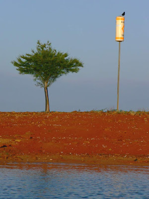
That cylinder under the crow--it's hard to tell but there's a nest under the crow as well--warns boaters of there being a shoal here.
No Friggin' Kidding???
It's like 18 feet above the water--the shoal itself is around 500 feet long. How could you miss it???
 Here's a picture of it from further back. The spit of land really is quite long and wide.
The sign usually has a more important role. It just looks funny now.
The water here in the Carolinas is quite low due to several years of drought. The lake level is down something like 16 feet as a result. Normally there's just a little bit of land above the water, right at the very base of that buoy.
At this point though, it's not a shoal, nor even an island. This spit of land is dry from one side of the shore to half way across the lake.
 In this picture you can see the lake on the other side of the "shoal". This is near the wet side of the shoal. It's only about 18 feet across here and maybe 4 feet above water.
The picture I had up the other day was from another 40 feet down where the shoal was finally ending.
It's a very popular place for fishing. There were 3 boats there while I was taking pictures.
 Sometimes they warn you of very real dangers, other times they're just there to cover someones butt--legally speaking.
And then there's the times when a sign is just out of date. That's the case here.
That cylinder under the crow--it's hard to tell but there's a nest under the crow as well--warns boaters of there being a shoal here.
No Friggin' Kidding???
It's like 18 feet above the water--the shoal itself is around 500 feet long. How could you miss it???
 Here's a picture of it from further back. The spit of land really is quite long and wide.
The sign usually has a more important role. It just looks funny now.
The water here in the Carolinas is quite low due to several years of drought. The lake level is down something like 16 feet as a result. Normally there's just a little bit of land above the water, right at the very base of that buoy.
At this point though, it's not a shoal, nor even an island. This spit of land is dry from one side of the shore to half way across the lake.
 In this picture you can see the lake on the other side of the "shoal". This is near the wet side of the shoal. It's only about 18 feet across here and maybe 4 feet above water.
The picture I had up the other day was from another 40 feet down where the shoal was finally ending.
It's a very popular place for fishing. There were 3 boats there while I was taking pictures.

Comments
Great pics. I love the red of the shoal againstt he blue of the sky and the water.